American Minute with Bill Federer: Miscalculation of Global Proportions led Columbus to attempt a voyage west

0
592

Columbus was looking for a SEA route to India and China because 40 years earlier Muslim Turks conquered Constantinople in 1453 cutting off the LAND routes.
A biography of Columbus was written by Washington Irving in 1828, titled A History of the Life and Voyages of Christopher Columbus.
In it, Irving created an imaginative dialogue of Europeans arguing over whether the Earth was round or flat. His book was so popular, that people actually thought such a debate took place when it had not.
Washington Irving was known for mixing entertainment with history and legend.
He wrote Rip Van Winkle, The Legend of Sleepy Hallow, and Diedrich Knickerbocker’s A History of New-York from the Beginning of the World to the End of the Dutch Dynasty, filled with tales of visits from St. Nick coining to New York City, which he nickname “Gotham.”
Europeans knew the Earth was round.
Pythagoras had speculated that the earth was a sphere in the 6th century BC, and Aristotle validated it in the 4th century BC.
In the 3rd century BC, Eratosthenes computed the circumference of the earth with amazing accuracy.
He had heard that at Aswan, Egypt, the sun cast no shadow at noon on the summer solstice, June 21, yet at the exact same moment in Alexandria, Egypt, a column cast a shadow with a 7.2 degree angle.
7.2 degrees is 1/50th of a 360 degree circle.
It was known that the distance between Alexandria and Aswan was 5,000 stadia or 800 kilometers (approximately 500 miles).
All Eratosthenes had to do was multiply 800 times 50, which equals 40,000 kilometers, just 75 kilometers less than the actual circumference of the Earth, 40,075 km, or 24,901 miles.
Eratosthenes also calculated distance to the sun and moon, the tilt of the earth, and created the first world map with parallel latitude and meridian longitude lines.
In the 1st century BC, Posidonius used stellar observations at Alexandria and Rhodes to confirm Eratosthenese’s measurements.
In the 2nd century AD, astronomer Ptolemy had written a Guide to Geography, in which he described a spherical earth with one ocean connecting Europe and Asia.
St. Isidore of Seville, Spain, wrote in the 7th century that the earth was round.
Around the year 723 AD, Saint Bede the Venerable wrote in his work Reckoning of Time that the Earth was spherical.
The Book of Isaiah 40:22 states:
“It is He that sitteth upon the globe of the earth.” (Douay-Rheims Bible)
Columbus knew the Earth was round, but the question was, how far around.
The confusion was over the length of a mile.
Columbus read Cardinal Pierre d’Ailly’s “Imago Mundi,” which gave Alfraganus’ estimate that a degree of latitude (at the equator) was around 56.7 miles.
What Columbus did not realize was that this was expressed in longer Arabic miles rather than in shorter Roman miles.
Therefore Columbus incorrectly estimated the Earth to be smaller in circumference, about 19,000 miles, rather than the actual nearly 24,901 miles.
Columbus knew there was land to the west, as he may have read Ptolemy’s account, written in 150 AD, of the Greek sailor named Alexander, who visited the Far East port city of Kattigara, beyond the Malay Peninsula (Golden Chersonese).
He could have heard of the Roman traveler, during the reign of Roman Emperors Antoninus Pius or Marcus Aurelius, who made his way to the court of the Chinese Emperor of the Han Dynasty.
Indeed, Roman glassware and medallions dating from this period were found at Guangzhou along the South China Sea, and at Óc Eo in Vietnam, near the Chinese province of Jiaozhi.
Great amounts of Roman coins were found in India, indicating there was Roman sea trade.
Columbus most likely heard the story of Irish monk St. Brendan, who sailed west in 530 AD to “The Land of the Promised Saints which God will give us on the last day.”
Columbus would have known of the Christian Viking Leif Erickson’s voyage in the year 1000 to Vinland (Newfoundland), called Markland in the Nordic Grœnlendinga Saga.
A Dominican friar in Milan, Italy, named Galvaneus Flamma, wrote an essay titled Cronica universalis, c.1345, in which he referred to the Icelandic description of a wooded land far to the west called Marckalada.
Columbus owned a copy of Marco Polo’s travels to China and India in 1271.
He studied Pliny’s “Natural History,” Sir John Mandeville, and Pope Pius II’s “Historia Rerum Ubique Gestarum.”
There were accounts that after the Crusades had ended, some Swedes in 1362 sailed to Greenland, and possibly beyond to North America, being the alleged background for the Kensington Runestone.
Columbus may have possibly seen maps, rumored to have been in Portugal’s royal archives, from China’s treasure fleets which were sent out in 1421 by Ming Emperor Zhu Di, led by Admiral Zheng He.
Columbus corresponded with Florentine physician Paolo dal Pozzo Toscanelli, who suggested China was just 5,000 miles west of Portugal.
Based on this, Columbus estimated that Japan, or as Marco Polo called it “Cipangu,” was only 3,000 Roman miles west of the Canary Islands, rather than the actual 12,200 miles.
Since no ship at that time could carry enough food and water for such a long voyage, Columbus would have never set sail if he had known the actual distance.
As a young man, Columbus began sailing on a trip to a Genoese colony in the Aegean Sea named Chios.
In 1476, he sailed on an armed convoy from Genoa to northern Europe, docking in Bristol, England, and Galway, Ireland, and even possibly Iceland in 1477.
When Muslim Turks conquered Constantinople in 1453 and hindered land trade routes from Europe to India and China, Portugal, which had been freed from Muslim domination for two centuries, began to search for alternative sea routes.
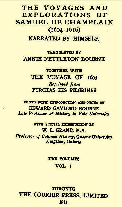
W.L. Grant, Professor of Colonial History, Queens University, Kingston, Ontario, wrote in the introduction of The Voyages
and Explorations of Samuel de Champlain (published 1911, The Courier Press, A.S. Barnes Company):
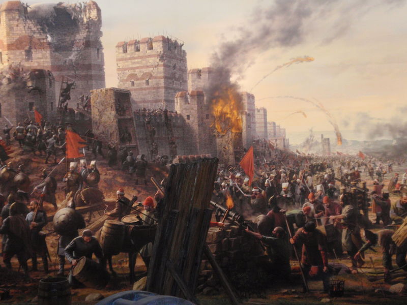
“The history of Western Civilization begins in a conflict with the Orient, a conflict of which it maybe the end is not yet.
But the routes between East and West have been trodden by the caravans of trade more often even than by the feet of armies.
The treasures of the East were long brought overland to Alexandria, or Constantinople, or the cities of the Levant, and thence distributed to Europe by the galleys of Genoa or of Venice.
But when the Turk placed himself astride the Bosporus, and made Egypt his feudatory, new routes had to be found.”
Socialist historian Howard Zinn admitted in A People’s History of the United States (1980):
“Now that the Turks had conquered Constantinople and the eastern Mediterranean, and controlled the land routes to Asia, a sea route was needed.
Portuguese sailors were working their way around the southern tip of Africa.
Spain decided to gamble on a long sail across an unknown ocean.”
Portugal, under Prince Henry the Navigator, led the world in the science of navigation and cartography (map-making), and developed a light ship that could travel fast and far, the “caravel.”
During Portugal’s Golden Age of Discovery under King John II, Columbus sailed along the west coast of Africa between 1482-1485, reaching the Portuguese trading port of Elmina on the coast of Guinea.
In 1498, Portuguese sailor Vasco de Gama did make it around South Africa to India.
But six years before that, in 1492, the Catholic Monarchs Ferdinand and Isabella finished driving the Muslims out of Spain and wanted to join the quest for a sea trade route to the India.
They backed Columbus’ plan.
Though Columbus was wrong about the miles and degrees of longitude, he did understand trade winds across the Atlantic.
On August 3, 1492, Columbus set sail on the longest voyage to that date out of the sight of land.
Trade winds called “easterlies” pushed Columbus’ ships for five weeks to the Bahamas.
On OCTOBER 12, 1492, Columbus sighted what he thought was India.
He imagined Haiti was Japan and Cuba was the tip of China.
He called the first island he saw “San Salvador” for the Holy Savior.
W.L. Grant continued in the introduction of The Voyages
and Explorations of Samuel de Champlain (1911, The Courier Press, A.S. Barnes Co.):
“In the search for these were made the three greatest voyages in history, those of Columbus, of Vasco da Gama, and greatest of all of Magellan.
In his search for the riches of Cipangu, Columbus stumbled upon America.
The great Genoese lived and died under the illusion that he had reached the outmost verge of Asia; and though even in his lifetime men realized that what he had found was no less than a new world.”
In his journal, Columbus referred to the native inhabitants as “indians” as he was convinced he had successfully arrived in India:
“So that they might be well-disposed towards us, for I knew that they were a people to be. ..converted to our Holy Faith rather by love than by force, I gave to some red caps and to others glass beads …
They became so entirely our friends that … I believe that they would easily be made Christians.”
Follow on:
William J. Federer videos
Schedule Bill Federer for informative interviews & captivating PowerPoint presentations: 314-502-8924 wjfederer@gmail.com
American Minute is a registered trademark of William J. Federer. Permission is granted to forward, reprint, or duplicate, with acknowledgment.

Leave a Reply

This site uses Akismet to reduce spam. Learn how your comment data is processed.